RESEARCH PROJECTS
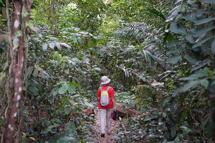 Photo credit: Marx Yim
Investigating the underlying drivers of Singapore’s loss and gains in urban green spaces from 1990-2020
Funding source: Singaporean Ministry of Education Tier 1 (Mar 2022 - Feb 2025)
Urbanization is a highly prominent land-use and land-cover change (LULCC) process in Singapore. This rapid LULCC has sparked some debates on the value of remaining green spaces in Singapore, whether these green spaces should be converted to urban extents, especially for housing, and what Singapore can do to balance the need for public green spaces and the demand for housing. This proposal takes a land systems science perspective to evaluate the mechanism of LULCC processes in Singapore, with a focus on the context of loss and gains of urban green spaces (UGS) in public lands. Land system science integrates different disciplines, especially across the natural and social sciences, to develop mechanistic explanations of land-change processes on Earth’s surface. Here, we bring together the disciplines of spatial sciences, sociology, ecology, and urban planning to develop a critical appraisal of the planning and use of public spaces in Singapore for public and private housing as well as urban greenery. We aim to (1) quantify the LULCC trends in public spaces, with attention paid to land used for public and private housing and for urban green spaces from 1990 to 2020, (2) evaluate the underlying drivers of these LULCC trends by linking these changes to Singapore’s land-use policies. We will first construct continuous land-cover maps for four time periods – 1990, 2000, 2010, and 2020 – at a 30-metre resolution using the geospatial cloud processing platform, Google Earth Engine. We will bring together land-use maps from the Singaporean land agencies and draw from government reports and published articles on land-use policies in Singapore. Understanding the underlying drivers of loss and gains in urban green spaces in Singapore is crucial to inform the many public debates about the value and use of these lands, especially considering recent land contestations for biodiversity conservation and public housing.
Co-PI: Zhan Shaohua (School of Social Sciences, NTU)
Collaborators: Shawn Kaihekulani Yamauchi Lum (ASE, NTU), Perrine Hamel (ASE, NTU), Kang Min Ngo (Green SG Collab)
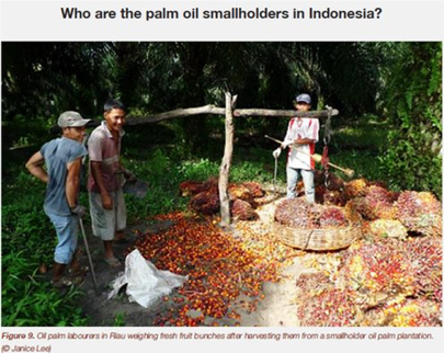 Photo credit: Janice Lee
Deforestation Risks in Commodity Supply Chains
Funding source: Singaporean Ministry of Education Tier 1 (Mar 2020 - Feb 2023)
The production of agricultural commodities such as soy, beef, and palm oil, is linked to distal consumer markets through a complex web of supply chains that span international boundaries. While the development of agricultural commodity industries has spurred economic growth for national and sub-national economies, it has also come under intense scrutiny as being the major driver of deforestation in the tropics. From a business perspective, firms, investors, and insurance companies are keen to reduce reputational, operational, and regulatory risks from deforestation in commodity supply chains. We aim to address deforestation risks within agricultural commodity supply chains by investigating how deforestation risks are introduced both in upstream and downstream segments of the supply chain. Specifically, we work on the palm oil industry in Sumatra, Indonesia and the cashew industry in Western Ghats, India (led by Anushka Rege).
Collaborators: Diana Chalil (Universitas Sumatra Utara, Indonesia), Judith Walls (University of St. Gallen, Switzerland), Conor Walsh (University of Greenwich, UK), Xingli Giam (University of Tennessee Knoxville, USA)
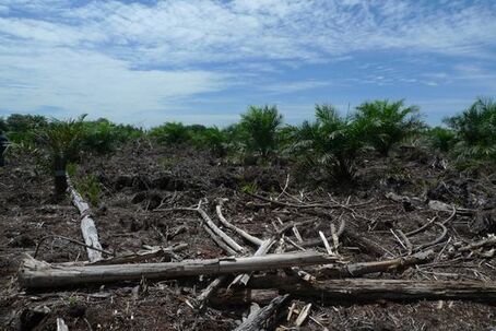 Photo credit: Janice Lee
Tropical Peatland Management and Restoration
Funding source: Singaporean Ministry of Education Tier 2 (Jul 2019 - Oct 2022)
The transboundary haze pollution is a major source of air pollution to Southeast Asian nations. At the heart of the haze lies the issue of tropical peatland degradation. The only long-term solution to effectively stop Southeast Asia’s haze is to protect remaining intact tropical peatlands, manage current land-use on peatlands, and restore degraded peatlands. However, the process of managing, protecting, and restoring peatlands is complex given the involvement of multiple actors and institutions, the different interactions of these actors and institutions with various components of the peatland ecosystem, and the varied spatial and temporal scales at which these interactions occur. We aim to understand how human-peatland interactions have evolved over time using case study approaches and fill the knowledge gap on peat revegetation success by understanding what plant traits contribute to successful peat revegetation. Lastly, we aim to evaluate how restoration programs help increase resilience of peatlands and communities. This work is led by Yuti Fatimah, Stuart Smith and Nur Estya Rahman.
 Photo credit: Janice Lee
Pengelolaan dan Restorasi Lahan Gambut Tropis
Sumber pendanaan: Kementerian Pendidikan Singapura Tingkat 2 (Jul 2019 - Okt 2022)
Pencemaran Asap Lintas Batas merupakan sumber utama polusi udara bagi negara-negara Asia Tenggara. Permasalahan asap ini terkait erat dengan masalah degradasi lahan gambut tropis. Satu-satunya solusi jangka panjang untuk menghentikan kabut asap secara efektif di Asia Tenggara adalah melindungi lahan gambut tropis yang masih ada, mengelola pemanfaatan lahan gambut saat ini, dan memulihkan lahan gambut yang terdegradasi. Namun, proses pengelolaan, perlindungan, dan restorasi lahan gambut ini rumit dengan adanya keterlibatan berbagai aktor dan institusi, interaksi yang berbeda dari para aktor dan institusi ini dengan berbagai komponen ekosistem lahan gambut, dan berbagai skala spasial dan temporal di mana interaksi ini terjadi. Kami bertujuan untuk memahami bagaimana interaksi manusia dan lahan gambut telah berkembang seiring waktu dengan menggunakan pendekatan studi kasus dan mengisi kesenjangan pengetahuan tentang keberhasilan revegetasi gambut dengan memahami sifat-sifat tanaman menyumbang terhadap keberhasilan revegetasi gambut. Akhirnya, kami bertujuan untuk mengevaluasi bagaimana program restorasi membantu meningkatkan ketahanan lahan gambut dan masyarakat. Studi penelitian ini dipimpin oleh Yuti Fatimah, Stuart Smith dan Nur Estya Rahman.
Co-PIs: Prof. David Wardle (NTU), Kwek Yan Chong (NUS)
Collaborators: Asmadi Saad, Hamzah, Richard Napitupulu (Universitas Jambi, Indonesia), Xingli Giam (University of Tennessee Knoxville, USA), Zaenuddin Prasojo (IAIN Pontianak, Indonesia), Laely Nurhidayah (LIPI, Indonesia), David Lallemant (NTU)
Collaborators: Asmadi Saad, Hamzah, Richard Napitupulu (Universitas Jambi, Indonesia), Xingli Giam (University of Tennessee Knoxville, USA), Zaenuddin Prasojo (IAIN Pontianak, Indonesia), Laely Nurhidayah (LIPI, Indonesia), David Lallemant (NTU)
See the following posters for updates on this work. Scan the QR code for an audio guide through the posters:
Socio-ecological restoration of South East Asian Peatlands (EN | BAHASA)
Peatswamp forest revegetation: Lessons learnt from a systematic review (EN | BAHASA)
Functional trait linkages between flammability and decomposability for tropical freshwater and peat swamp forest species (EN)
Check out this talk for an update on the projects pursued under this grant:
Hosted by the Institute of Water Policy, Lee Kuan Yew School of Public Policy, NUS
https://fb.watch/7p-LSOJVSr/
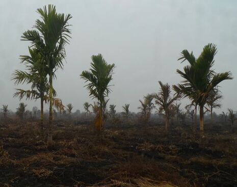 Photo credit: Janice Lee
Socio-ecological vulnerability of tropical peatland systems
Funding source: Earth Observatory of Singapore (Mar 2021 - Mar 2023)
We are interested to explore the dimensions of vulnerability for tropical peatlands using two approaches. Firstly, in a quantitative study, we borrow concepts from disaster risk science to design a probabilistic carbon loss framework of tropical peatlands to fires. This entails developing vulnerability curves, typically used to assess building damage losses in earthquakes, to assess how fires damages carbon loss in peat ecosystems. Secondly, in a qualitative study, we apply the double exposure framework to describe vulnerability of commodity frontiers happening over peatlands. This framework takes into account both the effects of capitalist expansion and climate change on the lives and livelihoods of communities living in these landscapes. This work is led by Yuti Fatimah and Nur Estya Rahman.
Co-PI: David Lallemant (NTU)
 Sarzynski et al. (2020) Rem Sens
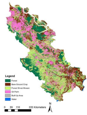
Data Analytics for Land-Use Processes
Observations of land-use processes are constantly made through the use of sensors in the sky and on the ground. The advent of social media as well as online platforms also provide a host of data sources which can be used to study land-use processes. Previously, we used publicly available satellite imagery in Google Earth Engine to map oil palm plantations in Aceh and the eastern coast of Sumatra. Using big data analysis, we are evaluating the drivers of fire activity at a global scale using the Global Fire Emissions Database (this work is led by Maple Wu) and exploring the use of online market platforms to map land prices in rural Indonesia (this work is developed together with Alejandro Coronado and OLX Indonesia).
Observations of land-use processes are constantly made through the use of sensors in the sky and on the ground. The advent of social media as well as online platforms also provide a host of data sources which can be used to study land-use processes. Previously, we used publicly available satellite imagery in Google Earth Engine to map oil palm plantations in Aceh and the eastern coast of Sumatra. Using big data analysis, we are evaluating the drivers of fire activity at a global scale using the Global Fire Emissions Database (this work is led by Maple Wu) and exploring the use of online market platforms to map land prices in rural Indonesia (this work is developed together with Alejandro Coronado and OLX Indonesia).
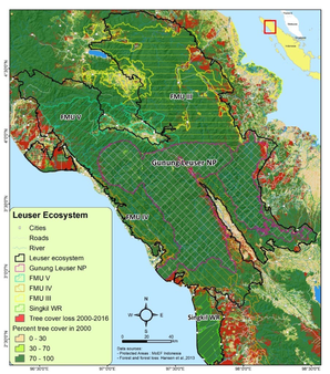 Photo credit: Muhammad Lubis
Conservation of forests and wildlife in human-modified landscapes
Deforestation threatens wildlife populations by removing their habitats, reducing their range sizes and food sources, and increasing the occurrence of human-wildlife conflict and poaching activity. To protect wildlife, it is crucial to stem deforestation and demonstrate how forests are important reservoirs of biodiversity and how they provide ecosystem services to human communities.
In Indonesia, we collaborate with the Wildlife Conservation Society to understand how forests contribute to watershed ecosystem services in the Gunung Leuser Landscape and how management interventions contribute to reducing human-wildlife conflict in this region. This work is led by Muhammad Lubis.
Collaborators: Matthew Linkie (WCS Indonesian), Bo An (NTU)
In India, Anushka Rege has been using a combination of traditional and newer methods such as bioacoustics to measure biodiversity in forests and heavily managed cashew plantations. More information on Anushka's project can be found in this Youtube video.
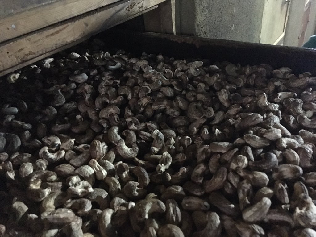
Photo credit: Janice Lee
|
Marathi explanation of Anushka’s project:
अनुष्का रेगे कोकणातल्या काजूंच्या विस्तारातील सामाजिक आणि पर्यावरणीय परिणामांचा अभ्यास करत आहे. काजू पुरवठा साखळीमुळे होणारी जंगलतोड समजून घेणे, काजू शेतकर्यांच्या जमीन व्यवस्थापन पद्धती समजून घेणे आणि जैवविविधता मिश्रित वन-काजू लँडस्केपचा कसा वापर करते हे समजून घेणे या प्रकल्पाचे हेतू आहेत. ती कॅमेरा ट्रॅपिंग, बर्ड पॉइंट गिनती, ध्वनिकी, संगणक-आधारित डेटा मॉडेलिंग यासारख्या पद्धतींचे संयोजन वापरते. |
CURRENT RESEARCH COLLABORATIONS
Using Black Soldier Flies in Food Waste Management and Sustainable Food Production in Urban Systems
This work is done in collaboration with researchers from NUS, SEC and NTU. Asst/Prof. Nalini Puniamoorthy from NUS leads this NRF-INTRACREATE Grant. More details on this project can be found here.
Agropolitan territories of Monsoon Asia
This work is done in collaboration with Professor Stephen Cairns at the Future Cities Laboratory which is a research collaboration between ETH Zurich and the Singapore universities, including NTU. It is supported by the National Research Foundation (NRF) Singapore. See here for more details.
Land-use transitions in Indonesian peatlands
This work is done in collaboration with researchers from the University of Maryland Center for Environmental Science and IPB-University. It is supported by NASA LCLUC program. See here for more details.
Riparian buffers in oil palm plantations: biodiversity refuge or pest source?
This work is done in collaboration with Assistant Professor Eleanor Slade who heads the Tropical Ecology and Entomology Lab at NTU Singapore. It is supported by a MOE Tier 1 grant.
PAST RESEARCH COLLABORATIONS
GreenPeat: Examing Peatland Fire Dynamics with AI and Earth Observation
This work was done in collaboration with Dr. Minerva Singh and Professor Guillermo Rein from Imperial College and supported by a seed grant through the NTU-Imperial Collaboration Fund.
Dam construction in Indonesia
This work was done in collaboration with Kai Wan Yuen, Prof. Edgardo Latrubesse, Asst/Prof. Edward Park from NTU and Prof. Muh Taufik, Prof. I. Putu Santikayasa, and Melda Hazrina from IPB-University.
Wildlife trade and consumption: Behavioural interventions for saiga horn consumption
This work was done in collaboration with Dr. Hunter Doughty and Professor EJ Milner-Gulland from the Oxford Martin School, University of Oxford. See here for more details.
